UAV flight routes optimized for turbulence and wind

Companies like amazon, matternet and many traditional transportation businesses are working on using UAVs (drones) to cover the last mile logistics to customers quickly and efficiently. While this approach promises huge improvements in efficiency, sustainability and time savings, it is not without its challenges. Urban flight routes need to be safe, and UAV flight corridors need to be selected in a way that allows consistent and disruption-free operation. We show you how to approach this from the perspective of urban wind.
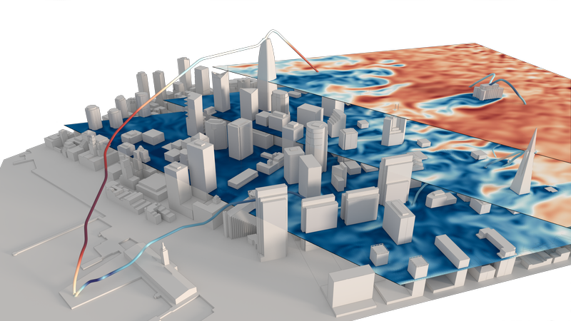
Enter: Airlane - our algorithm uses all the information about wind velocity, direction and turbulence to find optimum flight paths under the constraints explained below. This allows planning of urban flight corridors, landing sites, distribution centers, etc., using all the available information from prevailing wind conditions. Take a look at our video.
Wind in cities and the built environment behaves much differently to wind in natural landscapes. Cities have much bigger surface areas on the same ground area than what usually occurs in nature. There are plenty of sharp angles and narrow street canyons the wind has to flow through, much faster than it would be in free flow. The energy transported with that is substantial - the mass of air in a 1x1km downtown area of a city is around 120000 tonnes, and in a storm, all this mass moves at velocities beyond 80km/h.
When flowing through complex geometry, this generates turbulence, air is pushed between buildings, slows down in some places and is accelerated in others. In our article about wind movement and pressure around buildings, we demonstrate that tall buildings can easily increase air velocity by a factor of 4 beyond the highest gusts reported by the weather service. Enough to become dangerous to pedestrians, and more than enough to severely disrupt UAV flight corridors / operations already at much lower, everyday wind velocities.
Cities are a difficult environment to fly in and it is tough to find safe and efficient landing places and flight routes for UAVs (not only UAVs, but the problem is less pronounced for heavier aircraft like helicopters). The good news is that the air flow can be simulated, so that there is plenty of information available about air velocities and turbulence.
The next question, of course, is what to do with this information. We wanted to find out if we could design an algorithm that uses this information to find optimized flight paths through cities, allowing UAVs to avoid turbulence, keep a safe distance from obstacles, honor no-fly zones as well as maximum and minimum flight heights, minimize flight time and maximize speed under these constraints. This eventually resulted in Airlane and Airlane Cockpit, a software tool that allows you to do your own UAV route planning, including the influence of wind and turbulence.
While Airlane is currently available only as a demo for interested parties, we are happy to work with you if you want to plan for the future and explore ways to integrate air traffic into safe corridors in an urban environment. Here is a short video series that shows how it works:
If you are interested to take this further, contact us! We are happy to talk!
Published: